 When I was working as a bicycle tour guide in Paris in 2005, I used to pause the tourists in front of the Peace Monument to explain what I love most about Paris: how it’s urban design and architecture manage to cultivate both a deep sense of civic history and evoke the possibility of new and exciting futures simultaneously. The Peace Monument, purposefully placed in the center of the historic Champ de Mars (Field of War) in the first year of the new millennium, is a mostly-glass post-modernist monument with internet-driven interactive features and large columns with glass panels on which with the word “peace” is written in 32 languages. The monument is centered on a line between the Ecole Militaire and Tour Eiffel. The Ecole Militaire is the stone, neo-classical military school that educated Napoleon. Built in 1752, left pock-marked by Nazi bullets in 1944, it is a military monument to the country’s royal imperialism. To the northwest is the Tour Eiffel, constructed in 1889 to celebrate the 100-year anniversary of the French Revolution, it was built with such new technologies as machine riveting, new forms of architecture which called for the design and manufacture of thousands of unique, pre-fabricated steel pieces, and it’s structural engineering relied on tension, instead of compression. The Tour Eiffel was originally slated to be demolished in 1914, but was saved from demolition by its effectiveness in transmitting a new form of communication technology for French forces in WWI: radio.
The stone, neo-classical Military School of Louis XV from 1752; the steel Eiffel Tower built in 1889, celebrating the revolution from 1789 and broadcasting radio after 1914; the post-moderni Peace Monument projecting peace in 32 languages with internet-driven interactive features - all of these juxtaposed on the same field make one thing certain: Paris is not afraid of change. It is no museum like Venice. For another example, just look at the glass pyramid by I.M. Pei that was placed in the plaza of the Louvre in 1989. The power of Paris is its ability to constantly evolve without losing its identity.
A New ‘Grand Paris’

In September of 2007, President Sarkozy announced that it had commissioned a study of a “new comprehensive development project for Greater Paris.” city “new comprehensive development project for Greater Paris.” In June of 2008, 10 multi-disciplinary design and planning teams began a nine month design process to create new visions for the city. On March 17, the plans were unveiled at Musée de la Cité and a day-long public design critique was held in the great hall of Théâtre National de Chaillot. Actors from other major “metropolitan projects” (Greater London, Greater Madrid, Greater Berlin, etc.) were invited to critique the plans. The scale of the plans surpass that of Bloomberg’s massive PLANYC effort in New York and may represent the most grandiose re-visioning any major Western city has ever undergone, comparable perhaps to only the transformation of Paris under the direction of Baron Von Haussmann in the mid-19th century.
 Though the planning process was arguably no more open to public input than Haussmann’s was, these teams focused on largely on creating a greener and more equitable city. Most of the plans incorporated new transportation technology with large open-space projects. Antoine Grumbach proposed a new regional order, projecting along development of a new corridor stretching from Paris west to the French starchitect Christian de Portzamparc’s focuses building a new Paris that is the business center of Europe with a massive new regional rail station near a skyscraper-filled business center on the Parisian outskirts connected to an elevated mag-lev train that would run around Paris in a circle suspended above the busy lanes of the Parisian périphérique ring-road. The ultra-high speeds (360 + mph) that can be achieved through huge investment with mag-lev trains seems completely unnecessary for a circular commuter route which would likely have to stop frequently for good urban access.
Urban Plans for Racial Barriers

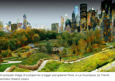
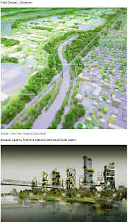
In 2005, while living in Paris, I photo-documented the weeks of riots by French-African youth, frustrated by the isolation and prejudice they faced in the baniliue and was struck by the way the rest of the country virtually ignored the chaos in these zones. Well, now planners are trying to improve the situation. Several of the plans, such as that of Jean Nouvel and Richard Rogers call for revitalizing poor, isolated areas with large French-African and immigrant communities with popular (though unproven) techniques of creating linear parks and community gardens to bridge physical and social barriers. What appears to be the most radical strategy, that of Roland Castro, who calls for moving Paris’s most iconic monuments, including the massive Élysée Palace, to the city’s most excluded outlying neighborhoods. Castro, The model for this strategy, as explained on the Atelier webpage (in French), is that of a Jackson Pollock painting where the entire fabric receives equal treatment , is unified, but also varied and full of surprises. A city of equality, but also a city built for derive, a space for the nonchalant noveau-flaneur. I admit, it does seem unduly disruptive to move such huge monuments from their historic places for a gesture that is largely symbolic. However, I am taken with the idea of expanding, diffusing, and de-centering the geography of Paris’s spectacular monumentalism - so integral to its identity - to the areas in the banilieu that are now just as much a part of Paris as any central arrondissemont.
Could a symbolic act, in this case the spatial diffusion of the monuments which create Paris's identity actually work to integrate communities that are currently excluded - spatially, socially, and economically - from broader French society? Certainly, it would not be an end-all solution. Of course, if it is poverty that concentrates African-French Parisians in crowded tenements in isolated areas of the banilieu, it is still the racial prejudice (rife within French society (well documented in hiring practices, for instance) that perpetuates cyclic poverty in this communities. While grand plans to bury the city’s largest train tracks and train yards under grand parks and gardens to integrate isolated neighborhoods (Richard Rogers) are reminiscent of Paris’s largest transformations of the past - the destruction of the old Parisian city wall in the 17th century and Haussmannian boulevards that were hacked through the medieval city in the 19th century – they may still be a small task in comparison with creating racial awareness in French society and addressing the gaps in equity.
These plans are a rallying cry to cities everywhere to be bold, artful, and radical in addressing the problems of the cities.
Note: though the Europe and American press insisit on refering to French-born citizens of African descent as “immigrants” ("immigré" in French). I refer to them throughout this piece as “African-French” since I have never been able to understand how it is propoer usage to address a French-born person as an "immigré" in France. “Citoyen” and "immigré" are used incorrectly used both in common parlance and by the press to “other” black French-African communities.


